


Shruti answered this
A magnetic compass is basically a needle made up of a magnetic substance which responds (moves) in the presence of magnetic fields. The needle is placed such that it is free to move in the horizontal plane along the vertical axis. The needle is kept in an enclosure with a transparent glass top.
It is normally used to detect the presence of electromagnetic fields or for navigation with respect to the Earth's magnetic poles.
Procedure to make a compass:-
(1) Take a needle of around one inch. Rub it against a magnet, rubbing should be in one direction.
(2) Get a piece of cork. It should be dry and clean.
(3) Stick the needle across cork. Be care full because the needle is sharp and you could injure yourself.
(4) Place the needle and cork in a glass of water, so piece of cork is able to float.
(5) Add some water to it, then wait to stabilize it you will find that stopped needle pointing north direction
- 1
Shobhita Shrivastava answered this
magnetic compass is an instrument which is used to find directions at a place.
- 0
Shivam answered this
The magnetic compass was first invented as a device for divination as early as the Chinese Han Dynasty (since about 206 BC).[1][2][3] The compass was used in Song Dynasty China by the military for navigational orienteering by 1040-1044,[4][5][6] and was used for maritime navigation by 1111 to 1117.[7] The use of a compass is recorded in Western Europe between 1187 and 1202,[8][9][10] and in Persia in 1232.[11] The dry compass was invented in Europe around 1300.[12] This was supplanted in the early 20th century by the liquid-filled magnetic compass.[13]
Contents- 1 Types of compasses
- 1.1 Magnetic compass
- 1.2 How a magnetic compass works
- 2 History
- 2.1 Navigation prior to the compass
- 2.2 Geomancy and feng shui
- 2.3 Navigational compass
- 2.3.1 China
- 2.3.2 Medieval Europe
- 2.3.3 Islamic world
- 2.3.4 India
- 2.3.5 Medieval Africa
- 3 Later developments
- 3.1 Dry compass
- 3.2 Bearing compass
- 3.3 Liquid compass
- 4 History of non-navigational uses
- 4.1 Building orientation
- 4.2 Mining
- 4.3 Astronomy
- 5 Modern compasses
- 5.1 Thumb compass
- 5.2 Gyrocompass
- 5.3 Solid state compasses
- 5.4 Specialty compasses
- 5.5 Limitations of the magnetic compass
- 6 Construction of a compass
- 6.1 Magnetic needle
- 6.2 Needle-and-bowl device
- 6.3 Points of the compass
- 6.4 Compass balancing (magnetic dip)
- 6.5 Compass correction
- 7 Using a compass
- 8 See also
- 9 Notes
- 10 References
- 11 External links

 A military compass that was used during World War I.
 There are two widely used and radically different types of compass. The magnetic compass contains a magnet that interacts with the earth's magnetic field and aligns itself to point to the magnetic poles.[14] Simple compasses of this type show directions in a frame of reference in which the directions of the magnetic poles are due north and south. These directions are called magnetic north and magnetic south. The gyro compass (sometimes spelled with a hyphen, or as one word) contains a rapidly spinning wheel whose rotation interacts dynamically with the rotation of the earth so as to make the wheel precess, losing energy to friction until its axis of rotation is parallel with the earth's. The wheel's axis therefore points to the earth's rotational poles, and a frame of reference is used in which the directions of the rotational poles are due north and south. These directions are called true north and true south, respectively. The astrocompass works by observing the direction of stars and other celestial bodies.
There are other devices which are not conventionally called compasses but which do allow the true cardinal directions to be determined. Some GPS receivers have two or three antennas, fixed some distance apart to the structure of a vehicle, usually an aircraft or ship. The exact latitudes and longitudes of the antennas can be determined simultaneously, which allows the directions of the cardinal points to be calculated relative to the heading of the aircraft (the direction in which its nose is pointing), rather than to its direction of movement, which will be different if there is a crosswind. They are said to work "like a compass", or "as a compass".
Even a GPS device or similar can be used as compass, since if the receiver is being moved, even at walking pace, it can follow the change of its position, and hence determine the compass bearing of its direction of movement, and hence the directions of the cardinal points relative to its direction of movement. A much older example was the Chinese south-pointing chariot, which worked like a compass by directional dead reckoning. It was initialized by hand, possibly using astronomical observations e.g. of the Pole Star, and thenceforth counteracted every turn that was made to keep its pointer aiming in the desired direction, usually to the south. Watches and sundials can also be used to find compass directions. See their articles for details.
A recent development is the electronic compass which detects the direction without potentially fallible moving parts. This may use a fibre optic gyrocompass or a magnetometer. The magnetometer frequently appears as an optional subsystem built into hand-held GPS receivers and mobile phones. However, magnetic compasses remain popular, especially in remote areas, as they are relatively inexpensive, durable, and require no power supply.[15]
Magnetic compassThe magnetic compass consists of a magnetized pointer (usually marked on the North end) free to align itself with Earth's magnetic field. A compass is any magnetically sensitive device capable of indicating the direction of the magnetic north of a planet's magnetosphere. The face of the compass generally highlights the cardinal points of north, south, east and west. Often, compasses are built as a stand alone sealed instrument with a magnetized bar or needle turning freely upon a pivot, or moving in a fluid, thus able to point in a northerly and southerly direction.
The compass greatly improved the safety and efficiency of travel, especially ocean travel. A compass can be used to calculate heading, used with a sextant to calculate latitude, and with a marine chronometer to calculate longitude. It thus provides a much improved navigational capability that has only been recently supplanted by modern devices such as the Global Positioning System (GPS).
How a magnetic compass works An inexpensive compass, aligned so that its needle points through the "North" mark on its compass card.
 A compass functions as a pointer to "magnetic north" because the magnetized needle at its heart aligns itself with the lines of the Earth's magnetic field. The magnetic field exerts a torque on the needle, pulling one end or pole of the needle toward the Earth's North magnetic pole, and the other toward the South magnetic pole. The needle is mounted on a low-friction pivot point, in better compasses a jewel bearing, so it can turn easily. When the compass is held level, the needle turns until, after a few seconds to allow oscillations to die out, one end points toward the North magnetic pole.
A magnet or compass needle's "north" pole is defined as the one which is attracted to the North magnetic pole of the Earth. Since opposite poles attract ("north" to "south") the North magnetic pole of the Earth is actually the south pole of the Earth's magnetic field.[16][17][18] The compass needle's north pole is always marked in some way: with a distinctive color, luminous paint, or an arrowhead.
Instead of a needle, professional compasses usually have bar magnets glued to the underside of a disk pivoted in the center so it can turn, called a "compass card", with a "compass rose" showing the cardinal points and degrees marked on it. Better compasses are "liquid-filled"; the chamber containing the needle or disk is filled with a liquid whose purpose is to damp the oscillations of the needle so it will settle down to point to North more quickly, and also to protect the needle or disk from shock.
In navigation, directions on maps are expressed with reference to geographical or true north, the direction toward the Geographical North Pole, the rotation axis of the Earth. Since the Earth's magnetic poles are near, but are not at the same locations as its geographic poles, a compass does not point to true north. The direction a compass points is called magnetic north, the direction of the North magnetic pole. Depending on where the compass is located on the surface of the Earth the angle between true north and magnetic north, called magnetic declination can vary widely, increasing the farther one is from the prime meridian of the Earth's magnetic field. The local magnetic declination is given on most maps, to allow the map to be oriented with a compass parallel to true north. Some magnetic compasses include means to manually compensate for the magnetic declination, so that the compass shows true directions.
In geographic regions near the magnetic poles, in the Arctic and Antarctic, variations in the Earth's magnetic field cause magnetic compasses to have such large errors that they are useless, so other instruments must be used for navigation.
The positions of the magnetic poles change over time, on a time-scale that is not extremely long by human standards. They wander over time-periods of only a few years, leading to corresponding changes of the directions of magnetic north and south as observed everywhere on the planet.
HistoryThe compass was invented in China, during the Han Dynasty between the 2nd century BC and 1st century AD.[1] The first compasses were made of lodestone, a naturally magnetized ore of iron.[3] Ancient Chinese people found that if a lodestone was suspended so it could turn freely, it would always point in the same direction, toward the magnetic poles. Early compasses were used for geomancy "in the search for gems and the selection of sites for houses," but were later adapted for navigation during the Song Dynasty in the 11th century.[3] Later compasses were made of iron needles, magnetized by striking them with a lodestone. The dry compass was invented in medieval Europe around 1300.[12] This was supplanted in the early 20th century by the liquid-filled magnetic compass.[13]
Navigation prior to the compass See also: Polynesian navigationPrior to the introduction of the compass, position, destination, and direction at sea were primarily determined by the sighting of landmarks, supplemented with the observation of the position of celestial bodies. On cloudy days, the Vikings may have used cordierite or some other birefringent crystal to determine the sun's direction and elevation from the polarization of daylight; their astronomical knowledge was sufficient to let them use this information to determine their proper heading.[19] For more southerly Europeans unacquainted with this technique, the invention of the compass enabled the determination of heading when the sky was overcast or foggy. This enabled mariners to navigate safely far from land, increasing sea trade, and contributing to the Age of Discovery.[citation needed]
Geomancy and feng shuiMagnetism was originally used, not for navigation, but for geomancy and fortune-telling by the Chinese. The earliest Chinese magnetic compasses were probably not designed for navigation, but rather to order and harmonize their environments and buildings in accordance with the geomantic principles of feng shui. These early compasses were made with lodestone, a form of the mineral magnetite that is a naturally-occurring magnet and aligns itself with the Earths magnetic field.[20]
Based on Krotser and Coe's discovery of an Olmec hematite artifact in Mesoamerica, radiocarbon dated to 1400-1000 BC, astronomer John Carlson has hypothesized that the Olmec might have used the geomagnetic lodestone earlier than 1000 BC for geomancy, a method of divination, which if proven true, predates the Chinese use of magnetism for feng shui by a millennium.[21] Carlson speculates that the Olmecs used similar artifacts as a directional device for astronomical or geomantic purposes but does not suggest navigational usage. The artifact is part of a polished hematite (lodestone) bar with a groove at one end (possibly for sighting). The artifact now consistently points 35.5 degrees west of north, but may have pointed north-south when whole. Carlson's claims have been disputed by other scientific researchers, who have suggested that the artifact is actually a constituent piece of a decorative ornament and not a purposely built compass.[22] Several other hematite or magnetite artifacts have been found at pre-Columbian archaeological sites in Mexico and Guatemala.[23][24]
Navigational compassA number of ancient cultures used lodestones, suspended so they could turn, as magnetic compasses for navigation. Early mechanical compasses are referenced in written records of the Chinese, who began using it for navigation sometime between the 9th and 11th century, "some time before 1050, possibly as early as 850."[25] A common theory by historians,[25][26] suggests that the Arabs introduced the compass from China to Europe, although current textual evidence only supports the fact that Chinese use of the navigational compass preceded that of Europe and the Middle East.[4]
China Further information: Four Great Inventions,List of Chinese inventions,andHistory of science and technology in China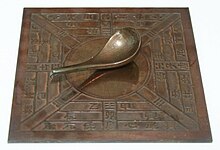 Model of a Han Dynasty (206 BC220 AD) south-indicating ladle or sinan. It is theorized[by whom?] that the south-pointing spoons of the Han dynasty were magnetized lodestones.[27]
 There is disagreement as to exactly when the compass was invented. These are noteworthy Chinese literary references in evidence for its antiquity:
- The magnetic compass was first invented as a device for divination as early as the Chinese Han Dynasty (since about 206 BC).[1][2][3] The compass was used in Song Dynasty China by the military for navigational orienteering by 1040-1044,[4][5][6] and was used for maritime navigation by 1111 to 1117.[7]
- The earliest Chinese literature reference to magnetism lies in the 4th century BC writings of Wang Xu (鬼谷子): "The lodestone attracts iron."[28] The book also notes that the people of the state of Zheng always knew their position by means of a "south-pointer"; some authors suggest that this refers to early use of the compass.[3][29]
- The first mention of a spoon, speculated to be a lodestone, observed pointing in a cardinal direction is a Chinese work composed between 70 and 80 AD (Lunheng), which records that "But when the south pointing spoon is thrown upon the ground, it comes to rest pointing at the south."[30] Within the text, the author Wang Chong describes the spoon as a phenomenon that he has personally observed.[31] Although the passage does not explicitly mention magnetism,[32] according to Chen-Cheng Yih, the "device described by Wang Chong has been widely considered to be the earliest form of the magnetic compass."[27]
- The first clear account of magnetic declination occurs in the Kuan Shih Ti Li Chih Meng ("Mr. Kuan's Geomantic Instructor"), dating to 880.[33] Another text, the Chiu Thien Hsuan Nu Chhing Nang Hai Chio Ching ("Blue Bag Sea Angle Manual") from around the same period, also has an implicit description of magnetic declination. It has been argued that this knowledge of declination requires the use of the compass.[33]
- A reference to a magnetized needle as a "mysterious needle" appears in 923-926 in the Chung Hua Ku Chin Chu text written by Ma Kao. The same passage is also attributed to the 4th century AD writer Tshui Pao, although it is postulated that the former text is more authentic. The shape of the needle is compared to that of a tadpole, and may indicate the transition between "lodestone spoons" and "iron needles."[34]
- The earliest reference to a specific magnetic direction finder device for land navigation is recorded in a Song Dynasty book dated to 1040-44. There is a description of an iron "south-pointing fish" floating in a bowl of water, aligning itself to the south. The device is recommended as a means of orientation "in the obscurity of the night." The Wujing Zongyao (武經總要, "Collection of the Most Important Military Techniques") stated: "When troops encountered gloomy weather or dark nights, and the directions of space could not be distinguished...they made use of the [mechanical] south-pointing carriage, or the south-pointing fish."[5] This was achieved by heating of metal (especially if steel), known today as thermoremanence, and would have been capable of producing a weak state of magnetization.[5] While the Chinese achieved magnetic remanence and induction by this time, in both Europe and Asia the phenomenon was attributed to the supernatural and occult, until about 1600 when William Gilbert published his De Magnete.[35]
- The first incontestable reference to a magnetized needle in Chinese literature appears in 1088.[6] The Dream Pool Essays, written by the Song Dynasty polymath scientist Shen Kuo, contained a detailed description of how geomancers magnetized a needle by rubbing its tip with lodestone, and hung the magnetic needle with one single strain of silk with a bit of wax attached to the center of the needle. Shen Kuo pointed out that a needle prepared this way sometimes pointed south, sometimes north.
- The earliest explicit recorded use of a magnetic compass for maritime navigation is found in Zhu Yu's book Pingchow Table Talks (萍洲可談; Pingzhou Ketan) and dates from 1111 to 1117: The ship's pilots are acquainted with the configuration of the coasts; at night they steer by the stars , and in the daytime by the sun. In dark weather they look at the south pointing needle.[7]
Thus, the use of a magnetic compass by the military for land navigation occurred sometime before 1044, but incontestable evidence for the use of the compass as a maritime navigational device did not appear until 1117.
The typical Chinese navigational compass was in the form of a magnetic needle floating in a bowl of water.[36] According to Needham, the Chinese in the Song Dynasty and continuing Yuan Dynasty did make use of a dry compass, although this type never became as widely used in China as the wet compass.[37] Evidence of this is found in the Shilin guangji ("Guide Through the Forest of Affairs"), published in 1325 by Chen Yuanjing, although its compilation had taken place between 1100 and 1250.[37] The dry compass in China was a dry suspension compass, a wooden frame crafted in the shape of a turtle hung upside down by a board, with the lodestone sealed in by wax, and if rotated, the needle at the tail would always point in the northern cardinal direction.[37] Although the European compass-card in box frame and dry pivot needle was adopted in China after its use was taken by Japanese pirates in the 16th century (who had in turn learned of it from Europeans),[38] the Chinese design of the suspended dry compass persisted in use well into the 18th century.[39] However, according to Kreutz there is only a single Chinese reference to a dry-mounted needle (built into a pivoted wooden tortoise) which is dated to between 1150 and 1250, and claims that there is no clear indication that Chinese mariners ever used anything but the floating needle in a bowl until the 16th-century.[36]
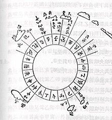 Diagram of a Ming Dynasty mariner's compass
 The first recorded use of a 48 position mariner's compass on sea navigation was noted in The Customs of Cambodia by Yuan Dynasty diplomat Zhou Daguan, he described his 1296 voyage from Wenzhou to Angkor Thom in detail; when his ship set sail from Wenzhou, the mariner took a needle direction of ding wei position, which is equivalent to 22.5 degree SW. After they arrived at Baria,[disambiguation needed] the mariner took "Kun Shen needle", or 52.5 degree SW.[40]Zheng He's Navigation Map, also known as "The Mao Kun Map", contains a large amount of detail "needle records" of Zheng He's expeditions.[41]
There is a debate over the diffusion of the compass after its first appearance with the Chinese. At present, according to Kreutz, scholarly consensus is that the Chinese invention predates the first European mention by 150 years.[4] However, there are questions over diffusion, because of the apparent failure of the Arabs to function as possible intermediaries between East and West because of the earlier recorded appearance of the compass in Europe (1190)[8] than in the Muslim world (1232, 1242, and 1282).[11][42] The first European mention of a magnetized needle and its use among sailors occurs in Alexander Neckam's De naturis rerum (On the Natures of Things), written in 1190.[8][10] The earliest reference to a compass in the Middle East is attributed to the Persians, who describe an iron fish-like compass in a talebook dating from 1232.[11] In the Arab world, the earliest reference comes in The Book of the Merchants' Treasure, written by one Baylak al-Kibjaki in Cairo about 1282.[42] Since the author describes having witnessed the use of a compass on a ship trip some forty years earlier, some scholars are inclined to antedate its first appearance accordingly. That the Arabic word for "Compass" (al-konbas) may be a derivation of the old Italian word for compass, is also used as evidence for the lack of diffusion from China to Europe. However, the Persian compass is described as fish-like, which is a characteristic of early Chinese compasses from the 11th century, suggesting transmission from China to Persia.[43]
Medieval Europe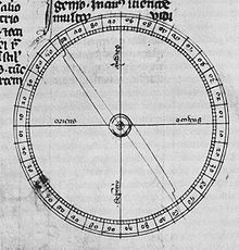 Pivoting compass needle in a 14th-century copy of Epistola de magnete of Peter Peregrinus (1269).
 Alexander Neckam reported the use of a magnetic compass for the region of the English Channel in the texts De utensilibus and De naturis rerum,[9] written between 1187 and 1202, after he returned to England from France[44] and prior to entering the Augustinian abbey at Cirencester.[45] In 1269 Petrus Peregrinus of Maricourt described a floating compass for astronomical purposes as well as a dry compass for seafaring, in his well-known Epistola de magnete.[9] In the Mediterranean, the introduction of the compass, at first only known as a magnetized pointer floating in a bowl of water,[46] went hand in hand with improvements in dead reckoning methods, and the development of Portolan charts, leading to more navigation during winter months in the second half of the 13th century.[47] While the practice from ancient times had been to curtail sea travel between October and April, due in part to the lack of dependable clear skies during the Mediterranean winter, the prolongation of the sailing season resulted in a gradual, but sustained increase in shipping movement; by around 1290 the sailing season could start in late January or February, and end in December.[48] The additional few months were of considerable economic importance. For instance, it enabled Venetian convoys to make two round trips a year to the Levant, instead of one.[49]
At the same time, traffic between the Mediterranean and northern Europe also increased, with first evidence of direct commercial voyages from the Mediterranean into the English Channel coming in the closing decades of the 13th century, and one factor may be that the compass made traversal of the Bay of Biscay safer and easier.[50] However, critics like Kreutz feel that it was later in 1410 that anyone really started steering by compass.[51]
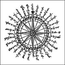 Navigational sailor's compass rose.
 At present, according to Kreutz, "barring the discovery of new evidence, it seems clear the first Chinese reference to" the compass "antedates any European mention by roughly 150 years."[4] However, there are questions over diffusion, because of the apparent failure of the Arabs to function as possible intermediaries between East and West because of the earlier recorded appearance of the compass in Europe (1190)[8] than in the Muslim world (1232, 1242, and 1282).[11][42] This is countered by evidence of the temporal proximity of the Chinese navigational compass (1117) to its first appearance in Europe (1190) and the common shape of the early compass as a magnetized needle floating in a bowl of water.[8]
- 0
Shruti answered this
A magnetic compass is basically a needle made up of a magnetic substance which responds (moves) in the presence of magnetic fields. The needle is placed such that it is free to move in the horizontal plane along the vertical axis. The needle is kept in an enclosure with a transparent glass top.
It is normally used to detect the presence of electromagnetic fields or for navigation with respect to the Earth's magnetic poles.
Procedure to make a compass:-
(1) Take a needle of around one inch. Rub it against a magnet, rubbing should be in one direction.
(2) Get a piece of cork. It should be dry and clean.
(3) Stick the needle across cork. Be care full because the needle is sharp and you could injure yourself.
(4) Place the needle and cork in a glass of water, so piece of cork is able to float.
(5) Add some water to it, then wait to stabilize it you will find that stopped needle pointing north direction
- 0