


Shubhankar Yogandra Kumar Mis... answered this
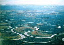
Mature rivers flow across wide river valleys and meander or snake across the flat plains. These meandering streams create large loop meanders that develop into oxbow lakes adjacent to the stream.
As a mature river begins to curve, it cuts and erodes into the outside of the curve and deposits sediment on the inside of the cure. This is due to the fact that the stream moves more rapidly on the outside of the curve and more slowly on the inside of the curve. Thus, as the erosion and deposition continues, the curve becomes larger and more circular.
- 5
Vineet Pashikanti answered this
- 1Geography
- 2Examples
- 3Artificial oxbow lakes
- 4See also
- 5References
- 6External links
An oxbow lake is formed when a river creates a meander, due to the river's eroding the bank through hydraulic action, abrasion and corrosion. After a long period of time, the meander becomes very curved, and eventually the neck of the meander will become narrower and the river will cut through the neck at a time of flood, cutting off the meander and forming an oxbow lake.
 An oxbow in the making:meandersand sandbank deposition on theNowitna River, Alaska
When a river reaches a low-lying plain, often in its final course to theseaor alake, itmeanderswidely. In the vicinity of ariverbend,depositionoccurs on theconvexbank (the bank with the smaller radius). In contrast, both lateralerosionand undercutting occur on thecut bankor concave bank (the bank with the greater radius.) Continuous deposition on the convex bank and erosion of the concave bank of a meandering river cause the formation of a very pronouncedmeanderwith twoconcavebanks getting closer. The narrow neck of land between the two neighboring concave banks is finally cut through, either by lateral erosion of the two concave banks or by the strong currents of aflood. When this happens, a new straighter riverchannelis created and an abandoned meander loop, called acutoff, is formed. When deposition finally seals off the cutoff from the river channel, an oxbow lake is formed. This process can occur over a time scale from a few years to several decades and may sometimes become essentially static.
Gathering of erosion products near the concave bank and transporting them to the convex bank is the work of thesecondary flowacross the floor of the river in the vicinity of a river bend. The process of deposition of silt, sand and gravel on the convex bank is clearly illustrated inpoint bars.[3]
River flood plains containing rivers with a highly sinuous platform will be populated by longer oxbow lakes than those with low sinuosity. This is because rivers with high sinuosity will have larger meanders and greater opportunity for longer lakes to form. Rivers with lower sinuosity are characterized by fewer cutoffs and shorter oxbow lakes due to the shorter distance of their meanders.[4]
The effect of the secondary flow can be demonstrated using a circular bowl. Partly fill the bowl with water and sprinkle dense particles such as sand or rice into the bowl. Set the water into circular motion with one hand or a spoon. The dense particles will quickly be swept into a neat pile in the center of the bowl. This is the mechanism that leads to theformation of point barsand contributes to the formation of oxbow lakes. The primary flow of water in the bowl is circular and the streamlines are concentric with the side of the bowl. However, thesecondary flowof theboundary layeracross the floor of the bowl is inward toward the center. The primary flow might be expected to fling the dense particles to the perimeter of the bowl, but instead the secondary flow sweeps the particles toward the center.
 Animation of the formation of an oxbow lake
The curved path of a river around a bend causes the surface of the water to be slightly higher on the outside of the river bend than on the inside. As a result, at any elevation within the river the water pressure is slightly greater near the outside of the river bend than on the inside. There is a pressure gradient toward the convex bank which provides thecentripetal forcenecessary for each parcel of water to follow its curved path. Theboundary layerflowing along the floor of the river is not moving fast enough to balance the pressure gradient laterally across the river. It responds to this pressure gradient and its velocity is partly downstream and partly across the river toward the convex bank.[3][5]As it flows along the floor of the river, it sweeps loose material toward the convex bank. This flow of the boundary layer is significantly different from the speed and direction of the primary flow of the river, and is part of the river'ssecondary flow.
When a fluid follows a curved path, such as around a circular bowl, around a bend in a river or in atropical cyclone, the flow is described asvortexflow: the fastest speed occurs where the radius is smallest, and the slowest speed occurs where the radius is greatest. The higher fluid pressure and slower speed where the radius is greater, and the lower pressure and faster speed where the radius is smaller, are all consistent withBernoulli's principle.
Examples[edit source|editbeta] Early stages of formation of coastal plain oxbow lake.Gower Peninsula, southwestWales
TheReelfoot Lakein westTennesseeis an oxbow lake formed when theMississippi Rivertook a new channel following theNew Madrid earthquakeof 18111812. There are many oxbow lakes alongside the Mississippi River and its tributaries. The largest oxbow lake in North America,Lake Chicot(located nearLake Village, Arkansas), was originally part of theMississippi River.
The Oxbow (Connecticut River), a 2.5-mile (4.0km) bend in theConnecticut River, is disconnected at one end.
The town ofHorseshoe Lake, Arkansasis named after the horseshoe-shaped oxbow lake on which it is located.
Cuckmere HaveninSussex,Englandcontains a widelymeanderingriverwith many oxbow lakes, often referred to inphysical geographytextbooks.
Kanwar Lake Bird Sanctuary,Indiacontains rare and endangered migratory birds and is one of Asia's largest oxbow lakes.
Carter Lake, Iowawas created after severe flooding in 1877 led to the river shifting approximately 1.25mi to the southeast.
Bole and Burton Round inWest Burton, Nottinghamshire,Englandare two good examples of previous lakes in a close proximity to one another
- -1